 I remember the moment very well, being on the radio at "Camp Casey" in Crawford, TX, where Cindy Sheehan was making her heroic call to meet face to face with George W. Bush, in late Summer of 2005. We were the only broadcast outfit doing regular daily broadcasts from on the ground there, as someone emailed me a warning from the National Weather Service about Hurricane Katrina on the night of Sunday, August 28, as the protest was wrapping up, and as the storm was gaining power and barreling towards New Orleans in the Gulf of Mexico.
The complete bulletin from the NWS was so alarming I wouldn't read it on air, at first, believing that surely it was a hoax. Only after going to commercial break, and checking it out for myself, did I then share it with listeners. It was shocking for such an announcement --- the NWS bulletins are usually rather straight, dry reads, as you probably know --- and included phrases such as "MOST OF THE AREA WILL BE UNINHABITABLE FOR WEEKS...PERHAPS LONGER."
Last night, the National Weather Service issued an equally remarkable bulletin in regard to Hurricane Sandy. That announcement, which includes this plea to those who may not wish to evacuate as instructed by authorities --- "IF YOU ARE RELUCTANT, THINK ABOUT YOUR LOVED ONES, THINK ABOUT THE EMERGENCY RESPONDERS WHO WILL BE UNABLE TO REACH YOU WHEN YOU MAKE THE PANICKED PHONE CALL TO BE RESCUED, THINK ABOUT THE RESCUE/RECOVERY TEAMS WHO WILL RESCUE YOU IF YOU ARE INJURED OR RECOVER YOUR REMAINS IF YOU DO NOT SURVIVE" --- follows in full below...
NATIONAL WEATHER SERVICE MOUNT HOLLY NJ
241 PM EDT SUN OCT 28 2012
...AN EXTREMELY DANGEROUS STORM TO IMPACT THE AREA...
SANDY IS EXPECTED TO SLAM INTO THE NEW JERSEY COAST LATER MONDAY NIGHT, BRINGING VERY HEAVY RAIN AND DAMAGING WINDS TO THE REGION. THE STORM IS A LARGE ONE, THEREFORE DO NOT FOCUS ON THE EXACT CENTER OF THE STORM AS ALL AREAS WILL HAVE SIGNIFICANT IMPACTS.
THIS HAS THE POTENTIAL TO BE AN HISTORIC STORM, WITH WIDESPREAD WIND DAMAGE AND POWER OUTAGES, INLAND AND COASTAL FLOODING, AND MASSIVE BEACH EROSION. THE COMBINATION OF THE HEAVY RAIN AND PROLONGED WIND WILL CREATE THE POTENTIAL FOR LONG LASTING POWER OUTAGES AND SERIOUS FLOODING.
PREPARATIONS SHOULD BE WRAPPING UP AS CONDITIONS ARE EXPECTED TO WORSEN TONIGHT AND ESPECIALLY ON MONDAY.
SOME IMPORTANT NOTES...
1. IF YOU ARE BEING ASKED TO EVACUATE A COASTAL LOCATION BY STATE AND LOCAL OFFICIALS, PLEASE DO SO.
2. IF YOU ARE RELUCTANT TO EVACUATE, AND YOU KNOW SOMEONE WHO RODE OUT THE `62 STORM ON THE BARRIER ISLANDS, ASK THEM IF THEY COULD DO IT AGAIN.
3. IF YOU ARE RELUCTANT, THINK ABOUT YOUR LOVED ONES, THINK ABOUT THE EMERGENCY RESPONDERS WHO WILL BE UNABLE TO REACH YOU WHEN YOU MAKE THE PANICKED PHONE CALL TO BE RESCUED, THINK ABOUT THE RESCUE/RECOVERY TEAMS WHO WILL RESCUE YOU IF YOU ARE INJURED OR RECOVER YOUR REMAINS IF YOU DO NOT SURVIVE.
4. SANDY IS AN EXTREMELY DANGEROUS STORM. THERE WILL BE MAJOR PROPERTY DAMAGE, INJURIES ARE PROBABLY UNAVOIDABLE, BUT THE GOAL IS ZERO FATALITIES.
5. IF YOU THINK THE STORM IS OVER-HYPED AND EXAGGERATED, PLEASE ERR ON THE SIDE OF CAUTION.
WE WISH EVERYONE IN HARMS WAY ALL THE BEST. STAY SAFE!
$$
NWS MOUNT HOLLY, NJ


 So Much Losing:
 'Green News Report' 4/23/26
 'A Scammer's Treasure Trove': DOGE Bros Stole Your Social Sec. Data: 'BradCast 4/22/26
 Insiders Making a Killing
 'Green News Report' 4/21/26
 Week 8: Iran War Lies Continue from Sundowning Gaslighter-in-Chief: 'BradCast' 4/20/26
 Sunday 'WWJD?' Toons
 U.S. Middle Eastern 'War Crimes' Then and Now: 'BradCast' 4/16/26
 Trump's USDA Takes Chainsaw to U.S. Forest Service: 'BradCast' 4/15/26
 Midterm Elections Reality Check:
 'Green News Report' 4/14/26
 Another Mad, Mad, Mad, Mad Weekend: 'BradCast' 4/13/26
 Sunday 'Mission Accomp...' Toons
 MAGA Buckles: 'BradCast' 4/9/26
 'Green News Report' 4/9/26
 Chaos, 'Ceasefire' Politics, Iran with Upper Hand: 'BradCast' 4/8/26
 Bye Bye Bondi (and It's TACO Tuesday Again!): 'BradCast' 4/7/26
 Trump Unhinging: 'BradCast' 4/6/26
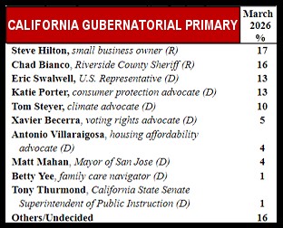 Potential Disaster for Democracy in Deep 'Blue' CA
 BRAD BLOG on the Move: Some good news for a happy change!...
 Trump Over a Barrel on Iran: 'BradCast' 3/25/26
 'Holding Out Hope' for SCOTUS on Late Mail Ballots: 'BradCast' 3/24/26
 FCC Chair Follows Instructions, Approves Unlawful Merger: 'BradCast' 3/23/26
 VA GOP VOTER REG FRAUDSTER OFF HOOK
 Criminal GOP Voter Registration Fraud Probe Expanding in VA
 DOJ PROBE SOUGHT AFTER VA ARREST
 Arrest in VA: GOP Voter Reg Scandal Widens
 ALL TOGETHER: ROVE, SPROUL, KOCHS, RNC
 LATimes: RNC's 'Fired' Sproul Working for Repubs in 'as Many as 30 States'
 'Fired' Sproul Group 'Cloned', Still Working for Republicans in At Least 10 States
 FINALLY: FOX ON GOP REG FRAUD SCANDAL
 COLORADO FOLLOWS FLORIDA WITH GOP CRIMINAL INVESTIGATION
 CRIMINAL PROBE LAUNCHED INTO GOP VOTER REGISTRATION FRAUD SCANDAL IN FL
 Brad Breaks PA Photo ID & GOP Registration Fraud Scandal News on Hartmann TV
  CAUGHT ON TAPE: COORDINATED NATIONWIDE GOP VOTER REG SCAM
 CRIMINAL ELECTION FRAUD COMPLAINT FILED AGAINST GOP 'FRAUD' FIRM
 RICK SCOTT GETS ROLLED IN GOP REGISTRATION FRAUD SCANDAL
 VIDEO: Brad Breaks GOP Reg Fraud Scandal on Hartmann TV
 RNC FIRES NATIONAL VOTER REGISTRATION FIRM FOR FRAUD
 EXCLUSIVE: Intvw w/ FL Official Who First Discovered GOP Reg Fraud
 GOP REGISTRATION FRAUD FOUND IN FL


